The difference between building near the Sunnyvale baylands and up against the foothills west of Highway 85 is night and day. Down by the water, you're on soft young sediments — bay mud and silty clays that have been settling for a few thousand years. Over toward the Santa Clara Valley floor, you hit older alluvial fans with gravel and stiff clay layers. A single seismic tomography line across that transition picks up velocity changes that tell us exactly where the competent material starts. We run P-wave refraction for shallow bedrock contours and combine it with reflection profiling when we need to image deeper fault structures. It's a direct way to avoid surprises before you even mobilize a drill rig. Before we deploy the geophone spread, we often review the site geology from existing boring logs and compare them with a resistivity survey to cross-check anomalies.
P-wave refraction picks bedrock contours accurately in Sunnyvale's alluvial fans; reflection reveals deeper fault structures below the bay mud.
Method and coverage
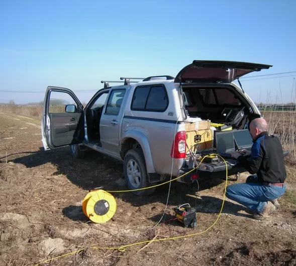
We roll out with a 24-channel seismograph and a spread of 4.5 Hz vertical geophones — the standard kit for shallow refraction in Sunnyvale's residential and commercial lots. The energy source is a 10-lb sledgehammer hitting a steel plate for near-surface work, or a 60-lb accelerated weight drop when we need deeper penetration. Each shot is stacked between 5 and 10 times to improve the signal-to-noise ratio, especially along busy corridors like El Camino Real or Mathilda Avenue where traffic vibration is constant. We also deploy a 3-component sensor at each end of the line to capture shear-wave refraction. That data feeds directly into the NEHRP site classification required by ASCE 7. For soft-soil zones near the Sunnyvale Water Pollution Control Plant, we complement the hammer source with a MASW survey to capture the shear-wave velocity profile down to 30 meters.
Technical reference image — Sunnyvale
Regional considerations
Sunnyvale sits on the Santa Clara Valley alluvial plain, but the San Andreas Fault runs less than 15 miles southwest. The 1989 Loma Prieta earthquake (M6.9) caused significant amplification across the bay mud deposits here — some areas saw peak accelerations double what the bedrock sites recorded. Seismic tomography gives you the velocity profile that determines site class per ASCE 7-22. If you're building within a quarter mile of the bay or near creeks like Calabazas or Stevens Creek, the soil column can include up to 12 meters of soft clay over stiffer sand. That velocity inversion is exactly what refraction picks up. We map the bedrock surface at depth to avoid foundation designs that underestimate cyclic softening or liquefaction potential.
2D velocity model, interpreted section, NEHRP site class
Related services
01
P-Wave Refraction Tomography
We deploy up to 48 geophones along a linear array and record first-arrival times from multiple shot points. The inversion produces a 2D velocity model that maps the top of bedrock, weathered zones, and velocity inversions. Typical for site class evaluation and shallow foundation design.
02
Shallow Reflection Profiling
Using a 24-channel landstreamer or fixed spread, we record reflected P-waves from deeper interfaces (typically 30–80 m). This method resolves fault strands, dipping layers, and lateral stratigraphic changes that refraction alone cannot image. Ideal for linear infrastructure projects.
03
Shear-Wave Refraction & MASW
We use a horizontal impact source and 3-component geophones to measure S-wave velocity profiles. The VS30 value feeds directly into NEHRP site classification. We integrate the results with standard refraction for a complete picture of stiffness and site response.
Standards that apply
ASTM D5777-18 (Standard Guide for Refraction Seismic), ASTM D7128-18 (Standard Guide for Reflection Seismic), ASCE 7-22 (Minimum Design Loads, Site Class Determination), NEHRP Recommended Provisions (FEMA P-1050)
Frequently asked questions
What is the difference between refraction and reflection seismic tomography?
Refraction uses first-arrival travel times of waves that bend through faster layers — it works best for mapping the top of bedrock and velocity inversions in the upper 30–40 meters. Reflection records waves that bounce off deeper interfaces (faults, stratigraphic boundaries) and can image down to 80 meters or more. In Sunnyvale, we often run both methods on the same line to cross-validate results.
How does seismic tomography help with NEHRP site classification?
The shear-wave velocity profile (VS30) is the primary parameter for assigning Site Class A through F per ASCE 7. Seismic tomography — specifically S-wave refraction or MASW — provides the velocity profile without requiring a borehole. In Sunnyvale's soft-soil areas, this is critical because the bay mud can drop VS below 180 m/s, pushing the site into Class E or F.
Can you run seismic tomography on a developed commercial lot in Sunnyvale?
Yes, with traffic control and short source-receiver offsets. We use a 10-lb hammer for near-surface work and keep geophone lines within 60 meters. Parking lots, sidewalks, and landscaped strips work well. We coordinate with the city for street closures when necessary, and we've completed lines along Mathilda Avenue and Sunnyvale-Saratoga Road without disrupting business operations.
What is the typical cost range for seismic tomography in Sunnyvale?
For a standard 24-channel refraction line with 48 geophones and 12 shot points, the cost typically falls between US$2,740 and US$5,020. That includes field work, data processing, inversion, and a report with 2D velocity sections and NEHRP site class. Reflection profiling or larger spreads add to the total. Contact us for a quote specific to your site geometry.